The St. Joseph County Council has a redistricting plan for 2022 after voting 6 to 3 along party lines Thursday night to override a Wednesday veto of the Democratic-proposed maps by the county commissioners.
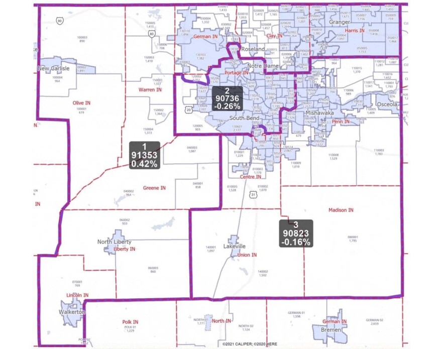
Last month, the all-Republican commissioners passed a controversial set of redrawn election maps, which created a heavily minority and Democratic South Bend based District 2 while making the other two districts whiter and more Republican.
The new District 1 includes all of Granger and the rural western portions of the county and the new District 3 includes all of Mishawaka, the southernmost portion of South Bend and the rural areas directly south.

Due to a change in Indiana law this year that only applies to St. Joseph County, the commissioners no longer needed the council’s approval to draw electoral maps — and all County Council districts must be drawn within County Commissioner districts.
That could potentially break the council’s current 6 to 3, veto-proof Democratic majority.
Council Democrats argue the new districts are unconstitutional and gerrymandered because they pack Black voters into the new District 2.
They are in the process of bringing a lawsuit against the maps after voting along party lines last month to hire Indianapolis law firm Ice Miller at a cost of up to $100,000. Their newly enacted county council redistricting plan contains three separate maps — one for each potential outcome of the suit.
Despite the veto override Thursday, Republican council member Mark Telloyan said he hopes both sides will keep talking.
“I have been in numerous situations where it seemed like there was an intractable difference,” Telloyan said. “As long as people kept talking and both sides kept making small changes, we eventually arrived at something that was disagreeable to everybody and agreeable to everybody.”
Council president Rafael Morton, a Democrat, agreed.
“Even though this is the 25th hour, I’m more than willing to sit down and compromise,” Morton said. “I have been willing from day one, and still remain that way.”
During public comment on Tuesday, Commissioner Derek Dieter said he would be open to a joint meeting about the maps but was unsure if Commissioners Andy Kostielney and Deb Fleming would participate.
“All I can do is ask them,” he said. “Hopefully they would, but [there are] political ideologies of one party over the other and, ‘We have to hold the line.’”
Dieter voted against the commissioners’ maps in November, attributing his vote to a lack of transparency in the process.
At the commissioners' meeting Wednesday afternoon, Kostielney said he had met with three council members that morning to discuss "any opportunity to maybe modify the maps and come to some kind of consensus."
Still, he and Fleming voted to veto the three-map ordinance.
"There were portions of this ordinance that I thought were well done, but quite frankly, any ordinance that's built on contingencies — I don't even know how it's viable," Kostielney said Wednesday. "It's very difficult for me to support something that is based on a series of events that we don't even know the answers to."
The three-map plan
The council’s first map hinges on population changes in the 2020 census.
Under current Indiana law, counties with a population between 250,000 and 270,000 have commissioners elected from three districts, and nine council members elected from districts within those districts.
But that effectively only applied to St. Joseph County, as it was the only county in Indiana to fall within that range.
The first map’s ordinance states that the statute violates the Indiana constitution, which includes language saying state legislators should not pass “local or special laws” governing the election of county officials.
But under the 2020 census, St. Joseph County now has 272,912 residents.
That means legally, county elections may need to be organized as they are in the majority of Indiana — three commissioners running in county-wide, at-large elections and a seven-member council made up of four council members running in districts and three running at-large.
The first map proposed by Democrats is in line with that statute and creates four council districts.

A bill passed during a special legislative session earlier this year temporarily froze population values at 2010 levels for determining the redistricting process.
But that means the commissioners used 2020 census data to draw the maps, but 2010 census data to determine the process for doing so — a bit of a paradox.
The second map would fall into place if courts find that the county council having nine districts is legal but strike down the enacted commissioner maps.
It includes nine council districts and three commissioner districts, both very similar to the maps that existed from 2011 to 2021.

The third proposal is for if the courts disagree with all legal challenges to the maps.
It draws nine council districts within the newly enacted commissioner districts and is most similar to the proposal Republican council members unveiled last week which would have created three Republican districts, three Democratic districts and three highly competitive districts.

Indiana law states redistricting must be complete by the end of the year. Candidates can begin filing for office in January.
Contact Jakob at jlazzaro@wvpe.org or follow him on Twitter at @JakobLazzaro.
If you appreciate this kind of journalism on your local NPR station, please support it by donating here.


