-
 The National Weather Service issued a tornado warning Tuesday at about 12:30 p.m. because of 70 mph winds near Plymouth but no tornadoes were reported.
 -
 The National Weather Service warns severe storms could bring damaging winds, large hail and possible strong tornadoes to Michiana through Wednesday.
 -
 One person was reportedly hurt, when the tornado destroyed a garage and caused roof damage at a home on Hyde Park Drive.
 -
 A cold front from the west collided with warm and humid air in Michiana Thursday night, creating high winds that caused property damage but no known injuries.
 -
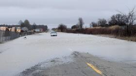 Flooding and high winds may pose some challenges in the coming days.
 -
 Milton Township Supervisor Eric Renken says it's the city of Niles, rather than the township, that activates township tornado warning sirens, but Friday's deadly tornado formed too quickly for radar detection and warnings.
 -
 “The potential’s there for six to 12 inches, and where this band anchors and kind of remains stationary, there’s a potential for amounts over a foot,” National Weather Service Northern Indiana Office Lead Meteorologist Nathan Marsili said in a YouTube update Saturday afternoon.
 -
St. Joseph County is upgrading its tornado siren system. Some people reported issues with the functionality of the sirens during last week's storms.
-
 The National Weather Service has confirmed that an EF1 tornado struck Bourbon Wednesday evening.
 -
 A powerful storm that swept through Michiana on Sunday left widespread damage, and the National Weather Service has confirmed at least one tornado.

© 2026 WVPE

Inform, Entertain, Inspire
Play Live Radio
Next Up:
0:00
0:00
Available On Air Stations


